The source of this transcription
is : http://files.usgwarchives.net/pa/schuylkill/history/local/day/001.txt.
It does not appear to exactly replicate the original, but is a very good work.
SCHUYLKILL COUNTY.
pp. 602 - 615
SCHUYLKILL COUNTY was separated from Berks and Northampton, by the act of 1st March 1811 Length 30 miles, breadth 20; area 745 sq. miles. Population in 1820, 11,339; in 1830, 20,744; in 1840, 29,053.
The surface of the county is very mountainous and rugged. A pleasant and fertile red- shale valley lies between the Kittatinny and Second mountains; but the region beyond, with the exception of the narrow val. leys of the streams, is of little value, comparatively, for agricultural purposes-the great wealth of that region consisting in its coal-mines. There are farms there, it is true, and more will be opened, stimulated by the excellent market in the immediate vicinity; but, as a general rule, the coal- region of Schuylkill county must look below the Second moun. tain, or even below the Blue mountain, for its agricultural supplies. The mountain ranges ran from southwest to northeast: the leading chains are the Kittatinny, or Blue mountain, which forms the southeastern boundary of the county; the Second mountain; Sharp mountain, which is the southeastern limit of the coal measures ; Mine hill, and Broad mountain, which contain the principal veins of coal; and the Mahantango and Mahanoy mountain, the northwestern boundary of the county.
The Schuylkill, with its branches, Little Schuylkill, Norwegian, and Mill Cr., is the principal stream of the county. The Swatara, the Mahantango, and Mahanoy creeks drain the southwestern end; and the sources of Catawissa Cr., Lizard, and Mahoning creeks are also within the county
The great southern anthracite coal-field is about 65 miles long, extending from the Summit mine of Mauch Chunk to the neighborhood of Pine Grove, where it divides into two branches: the northern one, under the name of Wiconisco mountain, extending westwardly beyond the county line to Lyken's valley, in Dauphin county; and the other embraced between the Stony mountain and a continuation of the Sharp mountain, reaching nearly to the Susquehanna. This coal-field is about five miles in width, between the northern slope of Sharp mountain and the southern slope of Broad mountain; and is divided by low ridges, or anticlinal axes, caused by subterranean forces, into the minor basins of Broad mountain, Mine hill, and Pottsville. Professor Rogers, the state geologist, remarks: From geological evidences, too numerous and striking to be questioned, we infer that all the coal deposits of our anthracite region owe their more or less inclined posture, and their limits, to the influence of two grand causes, namely subterranean elevation, and the superficial denuding action of a deluge." "Connected with this violent upheaving action of the coal strata, outside of the coal basins, enormous parallel wrinkling of the coal measures themselves have taken place, causing great intricacy in the internal structure of many parts of these regions. This is augmented by the existence of great dislocations, the results of the same subterranean movements." To the same cause Prof Rogers attributes the peculiar phenomena discovered in Sharp mountain, throughout an extent of probably thirty miles, indicating that the coal measures of that mountain have been tilted over backwards, or towards the north, breaking the coal up into small flakes, and giving to its strata a dip contrary to that which they should naturally have on the Southern side of the basin.
Broad and Sharp mountains, the boundaries of the basin, are cut down at various places, by the different streams that take their rise in the coalfield, or pass through it. It is penetrated by the Little Schuylkill, at Tamaqua, by the river Schuylkill at Pottsville, by the West Branch at Minersville, and by Swatara creek at Pine Grove; and at the west by the Wiconisco and Stony creeks. The northern boundary is also cut through by Roush's creek, a branch of Mahantango. These creeks, or passes through the mountains, afford outlets for the coal, and favorable sites for the location of canals and railroads. The principal of these improvements are the Schuylkill Navigation, penetrating the first coal-field at Pottsville, and terminating at Port Carbon; the Reading railroad, terminating, itself, at Pottsville, but connecting there with another railroad up the Schuylkill valley, ten miles-with the Danville and Pottsville railroad, and several other small roads diverging from Pottsville-and with the West Branch railroad at Schuylkill Haven, and the Little Schuylkill railroad at Port Clinton. The Union canal reaches near to the coal-field at Pine Grove, from which railroads diverge to the mines. These larger railroads have innumerable lateral branches, communicating with each different mine. Besides these improvements, there is an excellent stoned turnpike leading from Reading, through Orwigsburg and Pottsville, to Sunbury. Iron-ore of good quality has been found at a number of the coal-mines, and a successful attempt has been made, at Pottsville, in reducing iron-ore with the anthracite; but hitherto the coal business has been found the most profitable. The original population of the lower part of the county consisted of German farmers from Berks county; the greater part of the miners are Welsh and Irish, with a sprinkling of Scotch and Germans; and the trading classes in the coal-region are from Pennsylvania, New York and New England, and Ireland.
As early as 1790, a few quiet German farmers, among whom was the founder of Orwigsburg, had ventured up from the more thickly settled parts of Bucks county, into the red-shale valleys between the Kittatinny and Second mountain. These settlements increased, as all German settlements do, very slowly and surely, until the establishment of the county, in 1811, aided to build up the county town, and infused a more vigorous growth in the settlement. Still the region above Second mountain remained a desolate wilderness: a lonely road ran through the wild gorges, and over the Broad mountain, to Sunbury; and here and there was the cabin of some daring backwoodsman, or hardy lumberman, who kept an humble house of entertainment for the few who were compelled to go over the road. As for the lands that now sell for their $100,000, for a small tract, and pour forth annually their thousand tons of coal, if they had the honor of being owned at all, they were known only as the valueless property of some venerable German, or lone widow, who esteemed it a burden to pay the taxes. Some of them had been taken, and some of them had been refused, by city merchants, in payment for desperate debts. The following history of the discovery and introduction of the coal of this region into notice, is from a report made, in 1833. to the Coal Mining Association; and from a report to the state senate, in 1834, by Samuel J. Packer, Esq.
So early as 1790, coal was known to abound in this county; but, it being of a different quality from that known to our smiths as bituminous coal, and being hard of ignition, it was deemed useless, until about the year 1795, when a blacksmith, named Whetstone, brought it into notice, by using it in his smithery. His success induced several to dig for coal, and, when found, to attempt the burning of it; but the difficulty was so great that it did not succeed.
About the year 1800, a Mr. William Morriss, who owned a large tract of land in the neighborhood of Port Carbon, procured a quantity of coal, and took it to Philadelphia; but he was unable, with all his exertions, to bring it into notice. He abandoned all his plans, returned, and sold his lands to Mr. Pott, the late proprietor. From that time to about the year 1806, no further efforts to use it were made. About that time, in cutting the tail-race for the Valley Forge, on the Schuylkill, they struck on a seam of coal, which induced David Berlin, a blacksmith in the neighborhood, to make trial of it. His success was complete; and from that period it has been partially used.
In the year 1812, our fellow-citizen, Col. George Shoemaker, procured a quantity of coal from a shaft sunk on a tract he had recently purchased, on the Norwegian, and now owned by the North American Coal Company, and known as the Centreville mines. With this he loaded nine wagons, and proceeded to Philadelphia. Much time was spent by him in endeavoring to introduce it to notice; but all his efforts proved unavailing. Those who deigned to try it declared Col. Shoemaker to be an impostor, for attempting to impose stone on them for coal ; and were clamorous against him. Not discouraged by the sneers and sarcasms cast upon him, he persisted in the undertaking; and at last succeeded in disposing of two loads, for the cost of transportation. The remaining seven he gave to persons who promised to try to use it, and lost all the coal and charges. Messrs. Mellon and Bishop, at his earnest solicitation, were induced to make trial of it in their rolling-mill, in Delaware county; and finding it to answer fully the character given it by Col. Shoemaker, noticed its usefulness in the Philadelphia papers. From that period we may date the triumph of reason, aided by perseverance, over prejudice.
At this period the mountains were but partially explored, and the scant but hardy population of the county depended, in a great measure, on hunting, for their immediate wants; and on lumber for supplying those articles of foreign product that were required for their comforts or necessities. The lumber procured during the winter was formed into rafts, and sent down when spring freshets rendered the river navigable. By this uncertain and, at all times, precarious mode of conveyance, the product of this county was conveyed to market, until the canal was completed, in the year 1825.
In the year 1814, a few of the most enterprising of the citizens projected a canal from Philadelphia to this place, under an impression that the lumber of Schuylkill county, and the grain of the counties bordering on the Susquehanna, would find a vent, and ultimately aff'ord a dividend to the stockholders. At that period there were a few who looked forward to a time when the coal from this county would be the principal article of export, and would become an article of general use; but the number was small, and a vast majority looked on the formation of a Canal, through this wild and mountainous region, as a chimerical scheme, more fitted for speculators in a stock-market, than from any benefit that might result to the stockholders or the public.
In the year 1813, several small openings were made, in different, parts of the county, by sinking shafts ; and the coal taken out was vended to the smiths, and others in the neighborhood, at twenty-five cents per bushel, or $3 50 per ton, at the pit's mouth. These shafts were sunk but a few feet, in the crop of the vein, and the coal raised by means of the common windlass and buckets; and, so soon as they attained a depth where the water became troublesome, (which seldom exceeded thirty feet,) the shaft was abandoned and another sunk, and the same process undergone.
In the year 1823, an improvement, was made in the mode of working, in substituting horse power, by the gin, for the windlass heretofore used; by which they are enabled to clear the water from the shafts with greater facility, and to sink further on the veins. But with this (as it was then conceived) great improvement, they were only enabled to run down the vein for a short distance; and the coal, in point of comparison, was inferior-as experience has since taught that the crop is not equal to the coal that is taken out lower, and when the roof and door have attained the regularity and hardness so necessary to ensure good coal.
As far back as 1814, drifts had been run on the heads of veins, in several places. and the coal brought from them in wheelbarrows; but it was not until 1827 that the railroad was introduced into drifts. From that period to the present, drifts have been the universal mode. Improvements have been making from that to the present time; and it is believed thev have attained that degree of perfection which has so long been desired, and such as to enable thc miner to work on the beat and cheapest plan.
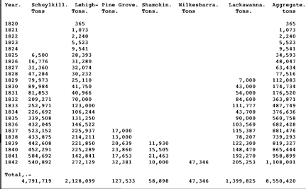
The Schuylkill Navigation Company were incorporated without mining and trading privileges; and hence it was, and of consequence must continue to be, their interest to invite tonnage from every quarter, and from every source. This valuable improvement, 108 miles in length. was commenced in 1815, and completed at an expense of $2,966,480. Tolls were first taken in 1818, amounting to $233 ; and from that time until 1825, it does not appear, from the annual reports of the company, that any account was kept of the tolls on the separate articles of tonnage, but that the whole amounted, for the ycar 1824, to $635. The next vear, 1825, at which period may be dated the commencement of the coal-trade on the Schuylkill, the tolls increased to $15,775. Of this sum $9,700 were received from coal. Having a free navigation, open to all who chose to participate in its facilities, and entering the first coal-field at its centre, individuals of capital and enterprise were attracted to the scene, and railroads constructed, diverging in all directions to the mines. Laborers and mechanics, of all kinds and from all nations, thronged to the place, and found ready and constant employment. A new era. seemed to have dawned in the mountains. The wilderness was subdued. The coal basin seemed to be literally running over with active and resolute adventurers; a rapidly growing population became established : the wild animal was driven back to give place to a host of miners, who now pierce its thousand hills. Houses, many of which are costly and splendid, and towns, the principal of which is Pottsville, sprang up in various parts of the region. Coal-lands, the basis of all this promising superstructure, grew rapidly in value. Being owned by numerous individuals, or yet remaining the property of the state, and considered until now scarcely worth the taxes, they were eagerly sought after, and presented strong inducements for the investment of capital. Sales were made to a large amount ; it being now estimated that four millions of dollars have been invested in lands in the first coal district. Many individuals purchased lands and removed upon them, with their families, designing to convert them into permanent residences ; and, as the farmer cultivates his farm, to prosecute the mining business with their own hands, and their own means. Other lands are held by capitalists, some residing in the district, and some at a distance; the mining operations being carried on by tenants. Associations of individuals, forming joint-stock companies, having obtained charters for the mining of coal, from the legislatures of other states, also purchased lands, which, to evade the statutes of mortmain, declared to be in force in Pennsylvania, were held in virtue of deeds of trust, and were used and occupied by those companies. Two of them, viz. the Delaware Coal Co. and the North-American Coal Co., were incorporated [in 1833] for the term of five years.
Capital was thus introduced, and important public improvements made. The country has grown and flourished beyond example. The farmer shared alike the general prosperity, in the now, convenient, and certain market for all his produce. In the midst of this hum of industry, this tide of prosperity, and flow of capital, it was not to have been expected that a spirit of speculation should have remained entirely dormant, or all who purchased lands did so with the bona fide intention either of occupying them themselves, by actual resident settlement, or of realizing their expenditures from the product of the mines. Hence a fictitious value was sometimes given to coal-lands. Calculations being made to ascertain the number of square yards of coal contained in an acre of land, and its value ; and some calculating also the quantity that each acre was capable of producing, without either knowing that it contained coal at all, or counting the cost, labor, and expense of producing it; the adventurer considered the sum of one, two, or three thousand dollars per acre a very inadequate price. The few who thus ran into error and extravagance, and purchased lands under these impressions, and with these expectations, (and is rather a matter of surprise that the number was not greater,) were reconciled either to lose money themselves, or impose their losses upon others. They were therefore interested in producing fluctuations and uncertainty, rather than steadiness and certainty, in the coal market. Their fortunes could not be injured by the most sudden change, but might possibly be benefited; and if a supply of coal were one year withheld, in order that the price might advance to ten, twelve, or fifteen dollars per ton, data would be afforded for another estimate of the value of their lands, by the square yard of coal, and the owner again realize, and perhaps double, the amount of his purchase money. These, however, are of the things that have been, and it is believed have now passed away. It is not now in the power of the speculator seriously to affect, nor of the Monopolist permanently to control, the coal- trade of Pennsylvania This mineral is happily too vast, and the facilities for transporting it to market too numerous and diversified, to be grasped by the hand of one or the other. At one time, and but a few years since. this might have been done, had the localities of our coal deposits been accurately known. But this knowledge was imparted in proportion as the interest or ambition of one impels him ahead of another, and as necessity leads to invention and discovery; and it is not now probable that such a state of things will ever occur.
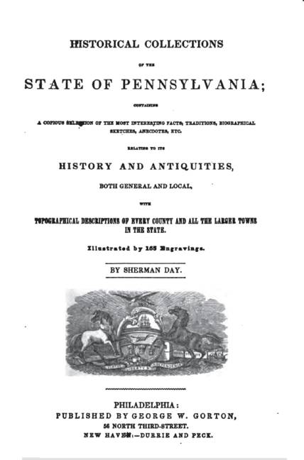
The following table exhibits the quantity of coal shipped for the different mining regions of Pennsylvania, from the commencement of the trade; together with the annual amount of increase and consumption, and quantity remaining over unsold, and disposed of on the line of the canal :-
Although mining coal for shipment was commenced in the Schuylkill region in 1825, five years later than the Lehigh, there has been 1,080,552 tons more sent to market from this region than from all the other anthracite regions in the state combined.
The magnitude of this trade well corresponds with the amount of capital invested in the different improvements of the region. Upwards of four millions of dollars have been invested in the following manner: 65 miles of incorporated railroads, 40 miles of individual railroads, 50 miles do. under ground ; 2000 railroad cars, 1500 drift cars ; 17 collieries below water level, with steam. engines, pumps, &c; 100 collieries above water level ; 80 landings; 850 canal boats ; 900 boat horses, &c. There are thirty-one steam-engines in the county, including colliery engines ,amounting to upwards of one thousand horse power. Twenty-three of these engines were manufactured in Schuylkill county. Previous to 1841, the horse-power was only 350 ; during the last two years there was an addition of 370 horse power, making, in the aggregate, 720 horse power engaged in collieries
ORWIGSIBURG, the county town, is a rural village, situated on the Reading and Sunbury turnpike, in a pleasant valley about five miles east of Schuylkill Haven, and five miles southeast from Pottsville. The town contains a courthouse and other public offices, situated on a spacious square in the centre, an academy incorporated in 1813, and a Lutheran church, of stone, erected about the year 1831.
Orwigsburg was laid out by Peter Orwig in 1796, but was not much settled until after the separation of the county from Berks, when it was made the county seat. It was incorporated as a borough 12th March, 1813. The population was, in 1820, 600; in 1830, 773; in 1840, 779. The citizens are chiefly of German origin, and speak that language. The public and private edifices are well built, and the village has a neat and quiet appearance ; while the smiling farms and verdant orchards around it denote the thrift of the German farmers. The history of such a people is soon told. They have cleared and cultivated their lands, attended to their own business, begotten sons and daughters, and been gathered to their fathers. Speculation has rattled and roared among the mountains beyond them, but has not seduced them from their persevering industry and frugal habits. Although the population of Pottsville and its vicinity far outnumbers that of the townships around Orwigsburg, yet the latter still retains its dignity as the county seat, in consequence of the balanced state of political parties. It is said that at the junction of the little creek that winds around Orwigsburg with the Schuylkill, was an ancient Indian village, on or near Scollop hill. No vestige of it now remains.
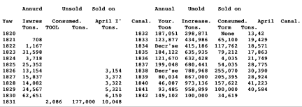
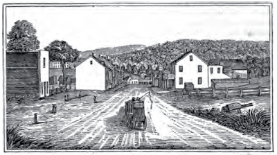
POTTSVILLE, the principal town of the county, and the great mart of the coal trade, is situated just above the gorge by which the Schuylkill breaks through Sharp mountain. The main branch of the river here comes in from the cast, and, receiving Norwegian creek from the north, turns suddenly to the south and flows away through the gorge. Pottsville proper, as seen in the accompanying view, occupies the northern slope of the mountain, and the valley of Norwegian creek. Immediately below it, on a narrow neck. along the turnpike, is Morrisville; near the junction of the streams, to the left of the point, is Greenwood ; and below the junction immediately in the gorge, is Mount Carbon. All these were incorporated on the 19th Feb. 1828, in the borough of Pottsville, which also includes what were once known as Bath, Salem, and Allenville. Pottsville is famous for its rapid growth, and the speculations that accompanied its origin. In 1822, the house since known as the White Horse tavern was kept by Mr. John Pott, who owned land in the vicinity, as a sort of watering-place for the stages on the Sunbury road. In 1824, we hear of five scattered dwellings in the vicinity. The causes which led to the influx of miners and speculators about the year 1825, have been described above. The town was soon laid out-or rather several towns for each prominent adventurer had his favorite location; and as each successive arrival of greedy adventurers tended to fan the flame of speculation, town lots and coal tracts (some with coal and many whose coal -was but imaginary) doubled, trebled, and quadrupled in value, and passed from hand to hand like currency. Houses were rapidly constructed to accommodate the immense crowds that came to search for lots and lands, and in 1828 we hear of several excellent stone houses and storm, others of brick and frame, a weekly newspaper, (the Miner's Journal,) a reading room, hotels, &c. Messrs. John and Benjamin Pott had also erected their Greenwood furnace and forge, and were making iron from ore obtained below the Blue mountain. The next year " Clinton row," on Mahantango St., and another row of houses, were erected; and such was the activity in building, that it became necessary to send to Philadelphia for lumber, to use in a region that hitherto had exported little else than lumber and coal. A daily stage to Philadelphia was also established in that year, and a trip of 14 hours was “cracked up" as something remarkable. A dozen little towns had already risen around Pottsville. Railroads also began then to be introduced, imparting a new impetus to the coal trade. The Schuylkill Valley, the Mill Creek, and the Mount Carbon railroads were started in that year. The following extract from the Miner's Journal for 1829, will give an idea of the rapid rise of coal lands.
Five years ago, [1824,] the "Peacock" tract of coal-land, belonging to the New York and Schuylkill Coal Co., was purchased by them for the sum of $9,000. Last week it was sold, and bought in by the original seller, for the sum of $42,000. The present owner, we understand, would not dispose of it for $70,000.
A tract of 120 acres, on the Broad mountain, was disposed of for the sum of $12,000; which was bought nine months ago for $1,400.
One fourth of another tract, of 450 acres, on the Broad mountain, has been disposed of for $9,000; at which rate the whole tract would be worth $36,000. But this estimate is too low. the remaining three fourths will bring that sum alone, at the present time. This tract was purchased, about six years ago, for $190.
A tract on the West Branch sold for $6,000, which was purchased nine months ago for $700. Another tract sold for $16,000, which was purchased nine months ago for $1,000.
All these sales have taken place within the last week, besides several others, of which we have not heard the particulars
In 1831, the number of buildings had increased to 535, of which there were 62 of brick, and 68 of stone; together with an Episcopal church, a meeting-house, and a beautiful structure for the Miners' Bank, of which the front is of cast-iron; and the commodious hotels of Mr. Seitzinger and Col. Shoemaker. There were also 70 stores, richly stocked, among which were those of two booksellers and stationers, and of tailors, milliners, and dressmakers. And they boasted too of a circulating library, a mechanics' library, and Exchange Reading-rooms; two newspapers; and a seminary, under the care of J. Sanderson, Esq. A writer in the Pottsville Advocate, early in 1831, thus speaks of the place. We make the extract by way of recording the names, that are contained in it, of some of the enterprising men of that day, and giving our readers an opportunity of comparing the state of things then with present appearances.
Northeastern View of Pottsville
The town of Pottsville, by the late census, contains upwards of 2,500 inhabitants. The fluctuating population having withdrawn, there may be a trifling decrease; for, at the time when the census was taken, we were thronged with strangers, drawn to the place by the ill-advised and premature uproar so foolishly raised about it. That, however, fortunately did no essential harm, and is an earnest that, for the future, it is not even in the power of our friends to injure us. We have now seventy stores, of various kinds, richly stocked, many of them rivaling those of Philadelphia in appearance.
Since last spring, about 50 new brick buildings have been erected in the town, more than half of which are large three-story houses. Among these are the uniform stores erected by James Appleton, at the upper part of Centre St. Jacob Alter has also erected three handsome stores, in the neighborhood of the Arcade.
Nor are our private houses less creditable to us than our public improvements. Among those which have lately been completed, we would mention Francis B. Nichols's and Abraham Potts's, on Market St., J. Sanderson's, Burd Patterson's, on Mahantango St., J. C. Offerman's, on Centre. St., and many others less remarkable; but imparting an air of neatness and comfort not often seen in towns of such rapid growth. In the lower part of the town, we have Themas Ridgeway's. and several others, comprising part of what is usually called Morrisville, which, with Mount Carbon, forms a striking entrance to the town from, the south.
We must not omit to mention M. B. Buckley's beautiful addition to Pottsville, distinguished by the name of Greenwood, occupying a point remarkable for its beauty, and the varied scenery which it commands. Among the improvements, we remark a large stone hotel, and a row of handsome stone houses. In the rear, on the river-road to Port Carbon, there is a large brewery, in full operation, established by A. Y. Moore, enabling us to boast of beer fully equal to that of Philadelphia.
Adjoining Morrisville, as we remarked above, stands Mount Carbon, which, under the fostering care of John White, now fully equals any part of the town in appearance. During the past season, many valuable additions have been completed; particularly a hotel, which would do credit to a city, and a row of stores. The Norwegian railroad terminates here.
Mount Carbon comprises the southern extremity of Pottsville. It stands on the Schuylkill, at the foot of the Sharp mountain, lying in the valley between that and Second mountain. Its situation is romantic; the abrupt hills, rising almost perpendicularly around, are strikingly grand; while the Schuylkill, winding through the gorges of the mountain, completes a scene of picturesque beauty unsurpassed by the points in whose praise our northern tourists are so fluent. Sharp mountain itself is a remarkable natural curiosity; resemibling a rampart-boundary to the coal region on the south.
The original town of Mount Carbon received considerable additions during the last year. Since the closing of navigation, the lock at the mouth of the canal has been renewed, under the superintendence of Mr. Mills, the agent for the Canal Co. In the pool above are the docks of Messrs. Ellmaker, Audenreid, and White and Coombe, who have two docks at the rear of their storehouses, each 28 feet wide; and in length one is 100 and the other 150 feet. Beyond are Mr. Eldridge's landings, adjoining the range now constructing for 'Mcsars. Theuron and, Macgregor. On the opposite side lie the boat- yards of Mr. Shelly, and the extensive landings of the North American Co. Again on the left are Mr. S. J. Pott's wharves; those of Messrs. Morris ; and Mr. C. Storer's boat- yard, on which we perceive he is erecting a screw-dock. The latter lie at the foot of Morrisville.
The pool below the bridge affords wharves to the storehouses of Messrs. Moore and Graham, Nathans, Thurston, and others. Several new landings are here constructing, the margin of the river presenting every facility for works of this nature. The principal buildings lately erected are a range of stone stores and dwelling-houses, the hotel on Centre-st. ; and on Market-st. six stone and twelve frame buildings. The hotel is a beautiful edifice of stone, 45 feet wide by 82, exclusive of the piazza, which presents a promenade to each story, embracing a view of the mountainous scenery around. These improvements are owing to the enterprising spirit of Messrs. White and Coombe.
The Mount Carbon railroad, projected as an outlet for the rich coal formations of the Norwe. gian creek valleys, was commenced in Oct. 1829, under the superintendence of William R. Hopkins, chief-engineer, and John White, president. At the termination the road is elevated upon 31 piers of masonry, erected upon the landings; thence it passes through the gap of Sharp mountain, across the landings before mentioned, following the valley of the Schuylkill to Morrisville. At this point we have, on the left, Messrs. Morris's mines, and on the opposite side of the river, on the Lippincott and Richards tract, the mines now worked by Mr. Baraclough. The road here leaves the Schuylkill, at its junction with the Norwegian creek, stretching up the valley of the latter, parallel with the Greenwood improvements, directly through Pottsville, to the forks: a distance of 6,208 feet from the piers. Below this are the mines now working by Mr. M'Kech. ney, and several openings on land belonging to D. J. Rhoads, Esq.
On the last branch, which is 14,200 feet in length, the first lateral above the forks belongs to the North American Co., and leads to their Centreville collieries, where they have twelve openings, upon the celebrated Lewis and Spolin veins. This coal is in high estimation, and has greatly aided in establishing the reputation of Schuylkill county coal, in the eastern markets. Beyond this, the road passes through Benjamin Pott's lands, and again strikes the Spohn vein at the east mines of the North American Co. The Hillsborough tract comes next, on the right, on which are several openings. Here we diverge to the left, through the celebrated Peach mountain tract, belonging to J. White, and pass five openings made by him. Next the Rose hill tract, owned by L. Ellmaker: on these lands are several mines, leased by the Messrs. Warner, Wade, and others, near the town of Wadesville: a thriving little place, laid out by Mr. Ellmaker. Above the town, the lateral road from Capt. Wade's mine comes down. The east branch terminates upon the Flowery field tract, belonging to Messrs. Bonsall, Wetherill, and Cummings. This land has been extensively worked by various individuals.
The West Branch commences at Marysville, on the Oak hill tract, and is 16,400 feet in length.
On this estate are the mines leased by Messrs. Smith, Hart, Maxwell, Wade, Hall, Dennis, Gallagher, and Martin. Among these are the celebrated Diamond and Oak hill veins. We must not omit the hotel kept here, by Mr. D. Gallagher, at a convenient distance from Pottsville for an excursion. Below Oak hill are the Green park and Clinton tracts; the former belonging to John White, and the latter to Mrs. Spohn. At Green park there is one opening under the superintendence of Mr.James Dill. Adjoining this is the Belmont estate-also John White's. Next the Thouron tract, a. portion of which has been purchased by Benj. Pott; the Spohn vein passing through it. Contiguous are the Spohn, Lewis, and Duncan estates. The railroad here passes B. Pott's saw-mill, and extends in a perfectly straight line, a mile in length, nearly to the junction with the main road.
Since the above extract was published, now twelve years, many important changes have taken place. Old mines have been exhausted or abandoned, and new ones opened; a great number of new railroads have been constructed; several mines have been explored, and profitably worked, below the water level. The geology of the region has been fully explored; the Pottsville, Reading, and Philadelphia railroad has been opened, in 1842, affording daily communication in seven hours to Philadelphia, and promising to effect a complete revolution in the transportation of coal; the speculations of 1836 have expanded and exploded. Pottsville has increased its population from 2,424 in 1830, and 3,117 in 1835, to 4,345 in 1840; and is now a compact, bustling place. Its trade, no longer driven back and forth by the tide of speculation, has settled, or is settling, into a steady channel, well understood, and well managed by capitalists, merchants, and miners. The town now contains a handsome Episcopal church, and a splendid new Catholic cathedral, both in the Gothic style; a German Catholic church, and neat edifices for the Presbyterian, Baptist, and Methodist denominations; an academy; a spacious town hall; a splendid hotel, called Pennsylvania Hall, and several other spacious hotels; a furnace, at which iron has been successfully made with anthracite coal; a forge and rolling-mill; a large foundry; a steam-engine factory and machine shop; a boat-yard, brewery, &a.
The Danville and Pottsville railroad, designed to connect the Schuylkill Navigation, at Pottsville, with the Susquehanna at Danville and Sunbury, was projected in 1826, and was completed in 1834 as far as Girardville, a small hamlet of three or four houses, ten miles north of Pottsville. Sixteen miles are also completed on the Sunbury end. The death of its chief patrons, the late Stephen Girard, and Gen. Daniel Montgomery, of Danville, with whom the project originated, has retarded the progress of the work. On the ten miles near Pottsville, a tunnel of 700 feet long, and four inclined planes, have been constructed at an enormous expense; but the tunnel 2,500 feet long, into the Girard coal-mines, on Mahanoy, is but partially completed. Until this is done, this part of the road cannot be profitably used, and the superstructure is now rotting in the sun. (A notice of the opening of the Reading railroad will be found on page 142.)
As the mines in favorable situations, above the water level, become exhausted, it is necessary either to seek new ones at a greater distance, and an increased cost of transportation, or to dive deeper into the bowels of the earth. The latter course has been adopted in several valuable mines, about Pottsville, by Mr. Charles Lawton, Messrs. Potts and Bannan, Mr. Charles Ellet, the Delaware Coal Co., Milne and Haywood, and Mr. George H. Potts, and others. Mr. Lawton is undermining the very town of Pottsville itself. These veins are inclined at an inclination of about 40". A wide shaft, or descending passage, is first sunk, at the inclination of the vein, wide enough, for a double-track railroad, upon which the loaded cars are hauled to the top of the mine. The Miners' Journal says, (in 1842)-
The colliery of Potts and Bannan is one of the most interesting of the kind in the region; and will well repay the trouble, and we might add the fatigues, of a visit. The colliery is better known as the Guinea hill, or Black mine, and is one of the deepest in our coal basin. The depth of the slope is 400 feet, which, at an inclination of 40 degrees. wouid give a perpendicular depth of 252 feet into the very bowels of the earth. The pitch of the vein, as soon as it loses the influence of the hill, is very regularl and the coal becomes of a purer and better quality, and is found in greater masses between the slates. The colliery is worked with two steam-engines one of fifty-horse power, and the other of twenty. The former is used in pumping the water which accumulates in the mines, and the latter in hoisting the coal in cars to the mouth of the slope. The pump used in the colliery is of cast-iron, 12 in diameter, and extends the entire depth of the slope-400 feet. The column of water brought up by the engine, at each lift of the pump, is equal in weight to about 81/2 tons.
At the depth of 200 feet of this slope, a tunnel has been driven 90 yards south to the Tunnel vein, and 70 yards north to the Lawton vein- both through solid rock; which enables the proprietors to work three veins, with the present engines and fixtures. As the visitor leaves the slope, and finds himself, lantern in hand, groping his way through the gangrway into the heart of the mine, he is half bewildered and startled, as the almost indistinct masses Of coal, slate, dirt, &c., fashion themselves into something bordering upon a dark, dusky, and even forbidding outline. It seems as if you had fallen upon a subterranean city, buried by some great convulsion of nature; and the illusion is still further heightened by observing workmen busily engaged, apparently in excavating the ruins. Or, if you are highly imaginative, and have read the Odyssey, you might readily fancy the feelings of Ulysses, that "godlike and much- enduring man," when he paid a visit to the infernal shades, for the purpose of ascertaining the shortest and most direct cut to his beloved Ithaca. Homer, however, does not inform us whether or not the shades carried lamps in their caps, without which the pick would be of little use to our miners.
PORT CARBON, (which must not be confounded by our readers with Mount Carbon,) is a very busy and thriving village on the main branch of the Schuylkill, two miles northeast of Pottsville, and at the head of the Schuylkill navigation. This place is happily located, surrounded almost by lofty mountains, well stored with the mineral wealth of the region, which can be conveyed to the landings with great facility. The town was laid out in 1828 by several enterprising individuals ; the lots adjoining the landings by Abraham Pott and Jacob W. Seitzinger: Lawtonville, adjoining to the westward, was laid out by Wm. Lawton, Esq. and Rhoadsville, on the continuation of the river Schuylkill, bv Daniel J. Rhoades, Esq. :-the whole of which constitute Port Carbon. Mill creek enters the Schuylkill here, and a railroad along its valley brings down the produce of the mines in the vicinity of St. Clairsville and New Castle. The Schuylkill valley railroad, with its numerous lateral intersections from the various openings in Mine hill. brings in a vast amount of coal. This road passes through the small villages of Patterson, Middleport, New Philadelphia and Tuscarora These villages were laid out about the year 1828, and have increased more or less according to the mining business near them
MINERSVII.I.E is beautifully situated, 4 miles N. W. of Pottsville, in the bosom of a valley through which meanders the western branch of the Schuylkill. It is the most important town on the West Branch. It contains a flouring-mill, steam saw-mill, foundry, car-manufactory, two or three neat churches, and 1,265 inhabitants. The West Branch railroad passes through the place. Nearly all the towns in Schuylkill co. were laid out by several different speculators, each preferring their own hill or valley, or landing place, as the Case might be, and each starting with a little cluster of frame houses. Consequently all such towns are like Washington city in one respect. cities "of magnificent distances." Minersville forms no exception to the remark- it consists of three or four once distinct settlements, now nearly merged in one. It was laid out in 1829, and in 1831 was incorporated as a borough. Its early growth was remarkably rapid, as will appear by the following from the Miner's Journal of Dec. 1830:
A little more than a twelvemonth ago, the present site of the town dwelt in all the loneliness of uncultivated nature, since which its aspect has undergone a wonderful change in improvements and population. Along the margin of the stream the West Branch railroad extends, and terminates at Schuylkill Haven, distance seven and a half miles from Minersville, affording an easy and expeditious mode of transportation. The principal street bears the name of Sunbury. on which are situated all the stores and public buildings. It was formerly the old Sunbury road, communicating with the rich valleys in the direction of the Susquehanna.. The northern portion of the village is of firm, dry soil, gradually rising, and affording a southern exposure- of favorable character for private dwellings. Seven large houses have already been erected during the present season on this spot by Messrs. Bennett & Gilmore, together with a number of small buildings in the same quarter. Last spring there were but six dwellings in all, since which there has been an increase of forty-nine substantial houses. The place contains six taverns, in any one of which are to be found respectable accommodations, eight stores, well supplied with every article for country consumption, six blacksmith shops, one saddlery, one bakery, two tailors' shops, and two butchers- all seeming to be in a thriving way. The population is estimated at 500 inhabitants. On Thursday evening, the 9th inst., a concert was given at Minersville by the diminutive songstress, Miss Clark, at which a numerous audience attended. Her warblings, a year ago, would have found an accompaniment in the uninterrupted solitude of a wilderness, instead of being listened to with marked pleasure by an animated and numerous assembly.
On the West Branch, about two miles west of Minersville, is the little village of Llewellyn, which obtained its name from the Welsh miners employed in the vicinity. Two and a half miles northwest from Llewellyn is the immense tunnel of the New York company now in progress, under the superintendence of Mr. Deforest, the company's agent. This tunnel, which is wide enough for a double track railroad, and has atready been driven about 900 feet directly into Broad mountain, is opened for the purpose of cutting the coal veins at right angles to their range. From the tunnel drifts are made at right angles to it into each vein of coal, and by means of these drifts the miners work out the breast of coal. But perhaps the reader who is a stranger to the anthracite re-ion mav not comprehend these terms. A tunnel among the miners is what has been described above. A drift is a passage barely wide enough for a horse and car, or man and car, to pass,--entering generally at the edge or end of a coal vein, and following its range nearly on a level. The coal veins in the anthracite region are generally inclined at angles varying from 30 to 60 degrees with the horizon, and usually crop out, or reach the surface of the hill, at a greater or less height. Sometimes they bend over the hill---or saddle over, as the term is- without coming to the surface at all. The height between the water level and the place where the vein reaches the upper surface of the hill, is called a breast ; and a vein is said to have more or less breast according to its height in the hill. The first practice in mining coal was by quarrying, as at Mauch Chunk; or by opening vast caverns, with columns of coal, as at Carbondale and Wilkesbarre; or by sinking shafts from the top of the hill, and hauling up the coal, as at first in Schuylkill co., and as still in use for mines below the water level; but all these modes have yielded to the easier and cheaper mode of drifting. The gorges of the small streams through Mine hill and Broad mountain offered the best sites for drifts. But many of these veins have been exhausted above the water level, as far as the owners on the streams have a right to work. Those who have no accommodating stream to cut through their land for them, are therefore obliged to adopt the mode of tunneling. The lateral drifts are generally let out to clubs of three or four miners in each, at so much per ton. These men drive their car in along the drift. One of them with his pick digs out the breast above the car in the shape of a broad chimney, letting his lumps fall against some rails placed it the foot of the breast; when a load is thus accumulated, the miner below draws one of the rails- the coal falls into the car, and is trundled out into the world. The miner thus keeps working upward till he reaches the out-crop. To prevent the mountain falling in where the coal has been taken out, stout props and cross-pieces are placed at intervals along the drift and the breast. This propping requires an immense quantity of timber, and the hills around Pottsville have been consequently despoiled of' their original forests. When a mine has been long exhausted and abandoned, these props decay, and the earth caves in. Lines of these unsightly holes begin to appear in many parts of the region about Pottsville- some of them for half a mile continuously.
On the West Branch, about three miles above Minersville, is a little miner's hamlet called Coal Castle. A little west of this place, at the “jugular vein” in Broad mountain, a coal mine took fire in the winter of 1838-39, and has since defied all attempts to extinguish it. It has even roasted the rocky strata of the mountain above it, destroying every trace of vegetation along the line of the breast, and causing vast yawning chasms, where the earth has fallen in, from which issue hot and sulphurous fumes, as from a volcano. The mine was ignited by a careless miner, who, to moderate the temperature, placed a hanging grate at the mouth of the drift. The fire communicated to the props, and then to the railroad, and such a heat was soon caused that it must have cracked off lumps of coal to feed the flames. It seems scarcely possible that the compact vein itself can be on fire, although such may be the case. Two unfortunate miners perished in the mine. The lessee, Mr. Dougherty, after trying various expedients to extinguish it, abandoned it, with a heavy loss.
NEW CASTLE, on the Sunbury turnpike, was laid out on the opening of the coal trade, and such houses as it has are substantially built of stone but it has increased very slowly.
SCHUYLKILL HAVEN is situated on the left bank of the river, four miles below Pottsville, and immediately below the junction of the West Branch. Fertile farms and very picturesque scenery surround the town, and the bright river here meanders among the broad meadows as if delighted with being unrestrained by the rocky precipices of the coal region. This place was laid out in 1829, by Mr. Daniel J. Rhodes and others. The West Branch railroad here communicates with the Schuylkill Navigation, and the transhipment of the coal has created a business, upon which the town has thrived. It now contains two or three churches, schools, a weigh lock for canal boats, a grist and saw mill, and two bridges across the Schuylkill. The population may be estimated at about 700. The county almshouse, one mile east of Schuylkill Haven, is a spacious brick edifice, with a fine farm attached, which does great credit to the county.
At Scollop hill, three miles below Schuylkill Haven, the canal passes through a long and expensive tunnel. The West Branch railroad brings in the product of many rich mines. It has been constructed in a substantial manner, and of such dimensions that the heavy cars of the Reading railroad, with which it here intersects, may run upon it. What effect this circumstance may have upon the welfare of Schuylkill Haven, by dispensing with the necessity of trailshipment, remains to be determined. In the annexed view, part of one of the churches is seen on the left- in the fore-round is the river and basin, with its numerous boats and rail-road tracks and a little beyond, on the right, is the bridge of the Reading railroad.
TAMAQUA was laid out in 1829, by the Lehigh Coal and Navigation Co. on the Little, Schuylkill river, 17 miles above its junction with the main stream, and 15 miles east of Pottsville. It lies in a deep valley, shut in by the Sharp and Locust mountains. It is now quite a smart village, with some half dozen stores, several taverns, two churches, a car and coach manufactory, and 465 inhabitants. It depends for its support upon the mines that surround it. Like the other coal towns, it is built on a scale of magnificent distances. There are several detachments, or regiments of houses, on the main road, up the river, down the river, and on the hill. Above the village, on a high eminence, stands the Catholic church, bidding defiance, as it were, to the Lutheran or Presbyterian church, which looks down from another eminence. The annexed view was taken at the western entrance of the street, on the Pottsville road. On the hill cast of the village, the large mansion erected by Mr. Burd Patterson, and now occupied by Mr. Franklin, makes quite a conspicuous appearance. The Lehigh Co. own large tracts of coal-lands in this vicinity. A continuation of the Little Schuylkill road, to connect with the Quakake and Catawissa railroad, was projected; but the Catawissa road has not been made. A stage-road connects Tamaqua with the Mauch Chunk rail-road, five miles east, and with the Schuylkill Valley railroad, four miles West.
Tamaqua
PORT CLINTON is a thriving place, laid out in 1829, at the mouth of Little Schuylkill river. It has grown up by the shipment here of the product of the mines around Tamaqua. PINE GROVE is situated on the right bank of the Swatara. creek, in the valley between the Kittatinny and Second mountains. about 14 miles west of Pottsville. A branch of the Union canal has been extended to this place; and a railroad extends up the Sawatara, four or five, miles, to the coal-mines on Lorberry creek, and the main branch of Swatara, above Sharp mountain. About 20,000 tons of coal were shipped from, this region in 1841. A forge has been established here since 1828. This region, before the coal-trade commenced, was settled by a few scattered German farmers and lumbermen, from Lebanon co.
Return
to the Schuylkill Region Development Page
About
The Hopkin Thomas Project
Rev.
July 2010